
Maine’s a beaut. Ain’t no doubt about it. She’s smart, too, and has quite the personality, but we can’t help stopping to stare at her rocky coast, cascading falls, and miles of mountaintops. No matter where you go in this state, there’s something unique to gawk at, but we’ve culled together a list of just some of the finest spots to get an eyeful of Maine. (And if you’ve got a favorite beautiful spot that’s not on the list, add it in the comments!)

Quoddy Head State Park
www.maine.gov | Google map
Home to red-and-white striped West Quoddy Head Light, Quoddy Head State Park stretches over 541 acres in Lubec. It’s the eastermmost point of land in the U.S. and, around the equinoxes, is the first spot in the country to see the sunrise.

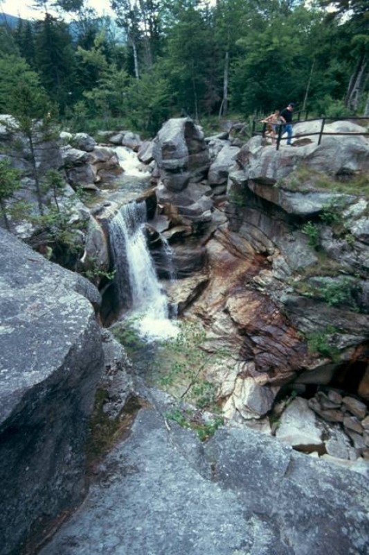
Coos Canyon
www.newenglandwaterfalls.com | Google map
The Swift River carved scenic, rocky Coos Canyon gorge through the bedrock of Byron. Some say gold can be found here but whether you leave with a nugget or not the natural views are worth the trip.

Baxter State Park
baxterstateparkauthority.com | Google map
More than 200,000 acres of wilderness and public forest make up this scenic park, which is home to Mt. Katahdin. Hikers will encounter plenty of wildlife and lush vegetation on more than 200 miles of trails. At 5,258 feet, Katahdin is Maine’s highest peak and the northern terminus of the Appalachian Trail.

Cadillac Mountain
www.nps.gov | Google map
Cadillac Mountain, part of Acadia National Park in Bar Harbor, is 1,532 feet of spectacular views. A winding, scenic 3.5-mile road brings visitors to the summit where many of the mountains on and around Mount Desert Island can be seen. From early October to early March it’s the first place in the U.S. to view the sunrise.

Cranberry Isles
www.cranberryisles.com | Google map
See the Cranberry Isles from Acadia National Park or visit them on a 30-minute ferry ride and look back on Mount Desert Island. Great Cranberry and Little Cranberry welcome visitors, but Bear, Sutton and Baker islands do not.

Monhegan Island
monheganwelcome.com | Google map
Located 12 miles off the coast, Monhegan Island is accessible by ferry from Boothbay Harbor, New Harbor and Port Clyde. Visit to walk the cliffs, view the lighthouses, chat with the islanders and observe the artists at work. Adjacent Manana Island is part of Monhegan Harbor.

Coastal Maine Botanical Gardens
www.mainegardens.org | Google map
Already one of the country’s most distinguished botanical destinations, CMBG is still a youngster after opening in 2007. New elements are added each year, and with trails and forests included in the layout, the non-profit is open year-round.

Moxie Falls, The Forks
www.newenglandwaterfalls.com/moxiefalls | Google map
Moxie Stream flows from Lake Moxie to the Kennebec River and the falls drop more than 90 feet into a deep pool. Find several plunges, cascades and pools along the way after making the 20-minute hike in.

Portland Head Light
www.portlandheadlight.com | Google map
Towering over Casco Bay in Fort Williams Park, Portland Head Light has long attracted tourists to Cape Elizabeth. The iconic lighthouse is Maine’s oldest and is recognized near and far. The park is open year-round with a small beach, rocky ledges and plenty of grassy recreation areas.

Kettle Cove
Google map
Sit on sand and gaze out to sea or sit on grass and take in the sights of Crescent Beach State Park. Sunsets are inspiring here and those relaxing can often watch local paddleboarders easing along atop the water.

Mt. Kineo
www.mooseheadlake.org | Google map
Looming beside Moosehead Lake in Piscataquis County, Mt. Kineo features 700-foot cliffs rising dramatically from the water. The mountain is made of hornstone and is the largest known mass of this rock in the nation. Find a viewing tower at the summit, where hikers can get spectacular views of the lake.
Gulf Hagas
www.northmainewoods.org/gulfhagas
Also known as the Grand Canyon of the East, Gulf Hagas is a gorgeous three-mile-long gorge on the Pleasant River, east of Moosehead Lake. “Prepare for a weekend of scenic waterfalls, hiking at its best and camping the way it’s supposed to be” when staying in the Gulf Hagas area, says Rhon Bell, outdoors blogger on mainetoday.com. Also-scenic Screw Auger Falls is also in the area – a fine pit stop on the way to the Gulf Hagas Rim Trail.

Otter Cliff
www.acadianationalpark.com/ottercliffs | Google map
The rocky shoreline of Monument Cove is nestled in just before Acadia National Park’s Otter Cliff, making the headland seem even higher than its 110 feet. Walk the Ocean Path and pass by powerful Thunder Hole on your way to the cliff where the views are unmatched.

Pemaquid Point Light
lighthouse.cc/pemaquid | Google map
The impressive lighthouse was selected by residents to represent Maine in the 50 State Quarters Program and is one of the most photographed on the Maine coast. The scenic landscape of the park includes exposed bedrock stretching to the sea and visitor’s can lounge on the rocks with the Atlantic below.

Two Lights State Park
www.maine.gov | Google map
Forty-one acres of rocky headlands make up the Cape Elizabeth park where rolling surf combines with sweeping views of Casco Bay and the Atlantic beyond. Stroll the small beach area or through the grasses atop the cliffs or climb along the rocks with a lighthouse in view.

Mt. Battie
www.maine.gov | Google map
Located in Camden Hills State Park, a drive up the Mt. Battie Auto Road reveals sweeping views of Camden, Penobscot Bay and surrounding islands. When the weather is clear, visitors can see all the way to Cadillac Mountain in Acadia National Park.

Mt. Megunticook
www.maine.gov | Google map
The highest of the Camden Hills offers plenty of hiking opportunities that lead to views similar to those atop Mt. Battie. Lake Megunticook sprawls below the peak, which is the highest on the mainland. The spot is particularly popular during leaf-peeping season when the surrounding hillsides are awash in fall colors.

Crescent Beach State Park
www.maine.gov | Google map
This Cape Elizabeth location has a little bit of everything – sandy beach, salty coves, grassy dunes, rocky ledges and shady wooded areas. It earned its name from the shape of the mile-long beach and is a perfect spot to watch for sea birds and fishing boats.

Popham Beach State Park
www.maine.gov | Google map
For a great view of the sandy beach and dunes, walk to neighboring Fox Island at low tide. Popham is bordered by both the Kennebec and Morse rivers and, in addition to Fox, Wood Island can also be seen from the shore. A stroll along the edge of the Atlantic may result in a treasure trove of sea shells.

Cutler Coast Public Reserved Land
www.maine.gov | Google map
A visit to Cutler Coast is an adventure filled with variety. Find blueberry barrens, woodlands and peatlands in 12,234 acres, along with 4.5 miles of headlands. Explore pocket coves and enjoy sightings of many species of birds. Sightings of seals, porpoises are whales aren’t uncommon during summer and fall.

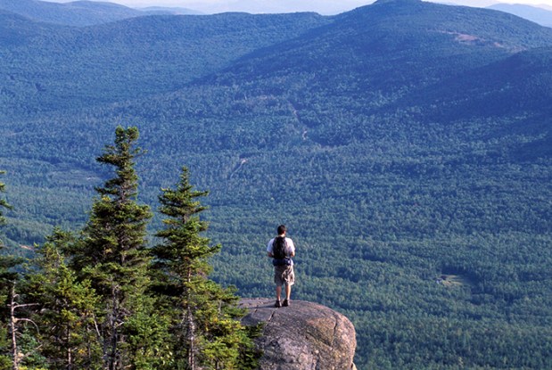
Table Rock
www.maine.gov | Google map
The hike to Table Rock, a granite ledge overlook, is short but challenging, and the views of Grafton Notch State Park are amazing. The park, located near Newry, contains 12 of the toughest miles of the Appalachian Trail and is a favorite destination of birdwatchers.
Screw Auger Falls
Screw Auger Falls
www.newenglandwaterfalls.com/screwaugerfalls | Google map
Take a walking path from Route 26 to this natural wonder in Grafton Notch State Park. The 23-foot waterfall follows a narrow gorge along the Bear River and offers shallow wading pools. The best view of the falls is from the rock ledge overlooking the gorge.
Tumbledown Mountain
Tumbledown Mountain
alltrails.com/tumbledown-mountain | Google map
Mountain, located in Franklin County. Several trailheads begin on Byron Road near Weld and views include Crater Lake just below the summit. Outdoors writer Josh Christie talked about Tumbledown in a story for the Portland Press Herald: “Many of Maine’s hikes allow access to dramatic cliff faces, Alpine ponds, bald ridges and closely-clustered peaks. One reason that Weld’s Tumbledown Mountain is my favorite hike in the state is because it offers all these features in one place.”
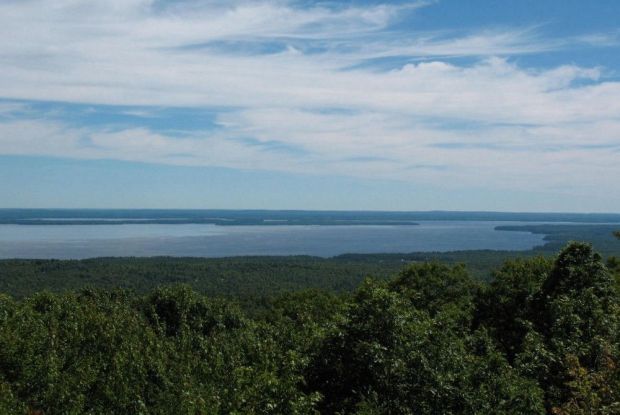
Sebago Lake
Sebago Lake from Douglas Mountain
alltrails.com/douglas-mountain-sebago | Google maps
Located near the town of Sebago, a stone tower at the summit of Douglas Mountain offers an expansive view of Sebago Lake that can’t be found elsewhere. In the other direction, see spectacular views of the White Mountains when the weather is clear.
Allagash Wilderness Waterway
www.maine.gov | Google map
Stretching for 90 miles, the Allagash Wilderness Waterway includes a plethora of natural sights, including 40-foot-high Allagash Falls, Twin Brook Rapids, Round Pond Rips and Churchill Depot. Views are best from the water but paddlers should use caution with frequent low water depths and exposed rocks mixing with rapids.
Height of Land
www.tripadvisor.com/heightofland | Google map
The Height of Land scenic overlook is a stopping point – and gawking point – on Route 17 near Rangeley. “Crowds can be found gathering at the Height of Land, where even on a hazy day the view pours over Mooselookmeguntic Lake and Toothaker and Students islands,” wrote Deirdre Fleming, staff writer at the Portland Press Herald. “On a good day the site lets a visitor travel in their mind over Rangeley and Cupsuptic lakes, west to the White Mountains and east to Saddleback Mountain. Dusk draws locals to see a sky full of shades of purple and orange.
http://mainetoday.com/maine-travel/most-beautiful-places-in-maine/

After leaving Maine to travel full time, this post really makes us eager to revisit some of our favorites on the list in the not too distant future 🙂 One place we’ve never made it to is Moosehead Lake and Mt. Kineo, so we’ll have to make that a priority too!